Taxon Details
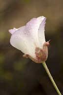
Calochortus simulans
La Panza mariposa-lily
View Report Copy Link Calflora eFlora CCH CalPhotos iNaturalist

© 2011 Aaron E. Sims |
© 2011 Aaron E. Sims |

© 2011 Chris Winchell |
Taxon Summary:
Calochortus simulans, commonly known as La Panza mariposa-lily, is a perennial bulbiferous herb in the Liliaceae that is found only in California. It occurs within Chaparral, Cismontane woodland, Lower montane coniferous forest, and Valley and foothill grassland, growing at elevations from 325 to 1150 meters. Calochortus simulans is ranked 1B.3, Plants Rare, Threatened or Endangered in California and Elsewhere; Not very threatened in California.|
Scientific Name: Calochortus simulans (Hoov.) Munz |
||
|
Common Name: La Panza mariposa-lily |
||
| Family: | Liliaceae | |
| Element Code: | PMLIL0D170 | |
| USDA Plants Symbol: | CASI7 | |
|
Synonyms/Other Names: |
||
| Name Status: |
JEF, FNA, POWO, IPNI, Tropicos |
|
| CA Rare Plant Rank: | 1B.3 |
| Fed List: | None |
| State List: | None |
| Global Rank: | G2 |
|
State Rank: |
S2 |
| Other Status: | BLM_S; SB_CRES; SB_SBBG; USFS_S |
|
CRPR Changes: |
|
| Add Date: | 1980-01-01 |
| Date Edited: | 2025-10-29 |
| Lifeform: perennial bulbiferous herb | ||||||||||||||
Blooming Period: Apr-Jun
|
||||||||||||||
|
Elevation:
325 - 1150 meters 1065 - 3775 feet |
||||||||||||||
General Habitats:
|
||||||||||||||
| Microhabitat Details: | ||||||||||||||
Microhabitat:
|
||||||||||||||
|
Notes: Threatened by grazing and development. Potentially threatened by road construction and mainetenance. Possibly threatened by recreational activities, vehicles, and non-native plants. Apparently intergrades with C. venustus. See Leaflets of Western Botany 4:4 (1944) for original description. |
|
|
Threats: |
|
|
Taxonomy: |
|
| Threat List Total: | 13 | |
| Total EOs | % of EOs | |
| EOs with Threat Listed: | 66 | 61 % |
| THREAT LIST: | ||
|---|---|---|
| Grazing | 34 | 31% |
| Non-native plant impacts | 16 | 14% |
| Improper burning regime | 15 | 13% |
| Other | 12 | 11% |
| Development | 10 | 9% |
| Road/trail construction/maint. | 9 | 8% |
| Erosion/runoff | 3 | 2% |
| Mining | 2 | 1% |
| Vandalism/dumping/litter | 1 | 0% |
| Feral pigs | 1 | 0% |
| Foot traffic/trampling | 1 | 0% |
| Recreational use (non-ORV) | 1 | 0% |
| Insufficient population/stand size | 1 | 0% |
| Total Occurrences: | 109 | ||||
| Element Occurrence Ranks: | |||||
|---|---|---|---|---|---|
| A | B | C | D | X | U |
| 5 | 30 | 24 | 9 | 0 | 41 |
| Occurrence Status: | |||||
|---|---|---|---|---|---|
| Historical >20 Years | 20 | ||||
| Recent <=20 Years | 89 | ||||
| Presence: | |||||
|---|---|---|---|---|---|
| Presumed Extant | 109 | ||||
| Possibly Extirpated | 0 | ||||
| Presumed Extirpated | 0 | ||||
| California Endemic: | |||||||||||||
| California Island: | |||||||||||||
|
States: Name (Code) California (CA) |
|||||||||||||
|
California Counties and Islands: Name (Code) San Luis Obispo (SLO), Santa Barbara (SBA) |
|||||||||||||
|
Quads: Name (Quad Code) Atascadero (3512046), Bates Canyon (3411988), Branch Mtn. (3512021), Bryson (3512171), Caldwell Mesa (3512023), California Valley (3512031), Camatta Ranch (3512043), Chimineas Ranch (3511928), Chimney Canyon (3512012), Creston (3512055), La Panza (3512032), Lime Mountain (3512068), Los Machos Hills (3512022), Miranda Pine Mtn. (3512011), Pebblestone Shut-in (3512161), Pismo Beach (3512026), Pozo Summit (3512033), San Luis Obispo (3512036), Santa Margarita (3512045), Santa Margarita Lake (3512034), Shedd Canyon (3512054), Tar Spring Ridge (3512024), Taylor Canyon (3511918), Tierra Redonda Mountain (3512078), Wilson Corner (3512044) |
|||||||||||||
Notes:
|
|||||||||||||
 Presumed Extant
Click on quad for name. Hold Shift Key to use mouse scroll wheel