Taxon Details
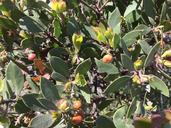
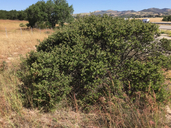
Arctostaphylos rudis
sand mesa manzanita
View Report Copy Link Calflora eFlora CCH CalPhotos iNaturalist

© 2022 David J. Keil |
© 2022 David J. Keil |
© 2022 David J. Keil |
Taxon Summary:
Arctostaphylos rudis, commonly known as sand mesa manzanita, is a perennial evergreen shrub in the Ericaceae that is found only in California. It occurs within Chaparral (maritime), and Coastal scrub, growing at elevations from 25 to 322 meters. Arctostaphylos rudis is ranked 1B.1, Plants Rare, Threatened or Endangered in California and Elsewhere; Seriously threatened in California.|
Scientific Name: Arctostaphylos rudis Jeps. & Wies. |
||
|
Common Name: sand mesa manzanita |
||
| Family: | Ericaceae | |
| Element Code: | PDERI043E0 | |
| USDA Plants Symbol: | ARRU2 | |
|
Synonyms/Other Names: |
||
| Name Status: |
JEF, FNA, POWO, IPNI, Tropicos |
|
| CA Rare Plant Rank: | 1B.1 |
| Fed List: | None |
| State List: | None |
| Global Rank: | G2 |
|
State Rank: |
S2 |
| Other Status: | BLM_S; SB_SBBG |
|
CRPR Changes: |
|
| Add Date: | 1980-01-01 |
| Date Edited: | 2025-10-29 |
| Lifeform: perennial evergreen shrub | ||||||||||||||
Blooming Period: Nov-Feb
|
||||||||||||||
|
Elevation:
25 - 322 meters 80 - 1055 feet |
||||||||||||||
General Habitats:
|
||||||||||||||
| Microhabitat Details: | ||||||||||||||
Microhabitat:
|
||||||||||||||
|
Notes: Plants on Nipomo Mesa (SLO Co.) have been determined to be a novel species, A. nipumu, with A. rudis becoming restricted to SBA Co. |
|
|
Threats: Threatened by development, agriculture, oil extraction, and road construction and maintenance. |
|
|
Taxonomy: Differentiated from A. nipumu by bark differences and presence of a basal burl. For additional information, see key provided in the A. nipumu original description (Phytokeys 251: 119-142 (2025)) |
|
| Threat List Total: | 8 | |
| Total EOs | % of EOs | |
| EOs with Threat Listed: | 8 | 40 % |
| THREAT LIST: | ||
|---|---|---|
| Development | 7 | 35% |
| Other | 3 | 15% |
| Improper burning regime | 2 | 10% |
| Non-native plant impacts | 2 | 10% |
| Grazing | 1 | 5% |
| Road/trail construction/maint. | 1 | 5% |
| Vandalism/dumping/litter | 1 | 5% |
| Wood cutting or brush clearing | 1 | 5% |
| Total Occurrences: | 20 | ||||
| Element Occurrence Ranks: | |||||
|---|---|---|---|---|---|
| A | B | C | D | X | U |
| 4 | 5 | 0 | 1 | 0 | 10 |
| Occurrence Status: | |||||
|---|---|---|---|---|---|
| Historical >20 Years | 12 | ||||
| Recent <=20 Years | 8 | ||||
| Presence: | |||||
|---|---|---|---|---|---|
| Presumed Extant | 20 | ||||
| Possibly Extirpated | 0 | ||||
| Presumed Extirpated | 0 | ||||
| California Endemic: | |||||||||||||
| California Island: | |||||||||||||
|
States: Name (Code) California (CA) |
|||||||||||||
|
California Counties and Islands: Name (Code) Santa Barbara (SBA) |
|||||||||||||
|
Quads: Name (Quad Code) Casmalia (3412075), Guadalupe (3412085), Lompoc (3412064), Lompoc Hills (3412054), Los Alamos (3412063), Orcutt (3412074), Point Arguello (3412056), Point Sal (3412086), Sisquoc (3412073), Surf (3412065), Tranquillon Mtn. (3412055) |
|||||||||||||
Notes:
|
|||||||||||||
 Presumed Extant
Click on quad for name. Hold Shift Key to use mouse scroll wheel